


Highlights of Feishida earthmoving calculation software
Improved accuracy: Compared with manual calculation, the error is significantly reduced, ensuring project safety.
Efficiency improvement: Automatically process terrain data, reduce manual intervention, and shorten the design cycle.
Cost Optimization: Through earthwork balance optimization, the amount of earthwork transported outside is reduced and the project cost is reduced.

Features of Feishida Earthwork Calculation Software
Efficient data conversion
Quickly identify CASS topographic maps, support the import of data files in multiple formats, and reduce the workload of manual entry.
Special terrain support
The feature line function accurately describes special terrain such as retaining walls and steep slopes, adapting to complex engineering needs.
Ocean Terrain Adaptation
Supports the conversion of terrain elevation data into negative values to meet the needs of special scenarios such as ocean ports.
Data Quality Check
Filter non-modular contours and discrete points to ensure computational data reliability.
Intelligent Design Control
Design control points and contours are automatically identified and elevations can be collected directly without discretization.
Automated Analysis Tools
Automatically generate natural triangle models, draw original surface profiles, and support multi-dimensional analysis (elevation, slope, aspect, etc.).

Feishida earthwork calculation software functions
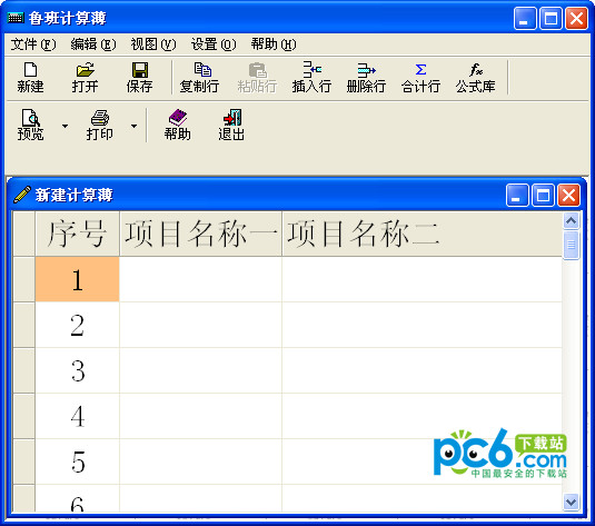
Six earthwork calculation methods
Square grid method: It is suitable for large-area flat sites and can calculate the amount of earthwork and stonework separately.
Triangulation method: Adapt to complex terrain calculations by constructing a triangulation model.
Section method: Suitable for long and narrow terrain or road projects.
Road Section Method: Designed specifically for roads, it supports cross-section earthwork volume calculations.
Field method: Quickly calculate earthwork balance for farmland or block areas.
Entire Estimation Method: An efficient tool in the preliminary estimating stage.
Topographic map data conversion
Automatically identify and convert elevation points and contour lines, and support the direct import of "Southern CASS topographic map".
Compatible with elevation data files in multiple formats (such as TXT, DAT, etc.).
Enter the thickness of the soil layer at the drilling point to assist in the calculation of the stone volume.
Elevation range checking function to ensure data accuracy.
Slope processing function
Multi-level grading: Generate multi-level slopes at one time to reduce manual intervention.
Refined processing of corners: Automatically optimize the grading at corners to avoid design defects.
Red line boundary control: Automatically determine the starting grading boundary based on the red line of the land.
Special Terrain Treatment
Characteristic line function: Accurately describe complex terrain by drawing characteristic lines such as scarps, retaining walls, and slope protection.
Elevation collection optimization: With the assistance of characteristic lines, elevation data is more accurate and calculation efficiency is improved.
Site design elevation determined
Automatically collect design elevation data and support parameterized input.
Balance site optimization: Automatically adjust the elevation through algorithms to achieve earthwork balance.
Trial calculation function: quickly verify the earthwork volume of different elevation plans.
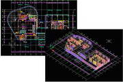
Three-dimensional site analysis and design
Generate triangular surface models to support elevation, slope, and aspect analysis.
The three-dimensional excavation and filling effect is visualized to intuitively display the project results.

Frequently Asked Questions about Feishida Earthwork Calculation Software
The grid layout is incomplete (does not reach the boundary)
Problem phenomenon: The grid layout of the site is incomplete and cannot fully cover the boundaries.
Cause analysis: There is a fold line at a node of the site boundary range line, which prevents the square grid from extending to the boundary smoothly during layout.
Solution: Get rid of the polygonal lines at the boundary of the site and straighten them to ensure the standardization and continuity of the boundary lines. The area blocks are then rearranged and a new grid is generated.
Feishida earthmoving calculation software update log:
1. Optimize content
2. The details are more outstanding and bugs are gone.
Huajun editor recommends:
The editor guarantees that as long as you use Feishida earthwork calculation software, if you don't like it, you can come and hit me! The editor has also prepared for youFuture list pricing,Concrete mix ratio calculator,Southern total station transmission software,Aiyifang login platform,Changfeng rental software


Your comment needs to be reviewed before it can be displayed