If you are looking for software to use, go to Huajun Software Park! software release AI product list

Hello, if there is a need for software inclusion, please package the software and attach the software name, software introduction, software-related screenshots, software icon, soft copy, business license (if you do not have a business license, please provide the front and back of the corresponding developer ID card and a photo of yourself holding the ID card), and send it to email http://softwaredownload4.com/sbdm/user/login

Close >>

Send to email:news@onlinedown.net

Close >>

Location: Home pagePC softwareEducation and teachingAstronomy and geography Geographic Information Data Download (DEM) Assistant
Geographic Information Data Download (DEM) Assistant

Geographic information data download (DEM) assistant v2017 official version

QR code
  • Software licensing: free software
  • Software size: 28.8MB
  • Software rating:
  • Software type: Domestic software
  • Update time: 2024-12-30
  • Application platform: winall
  • Software language: Simplified Chinese
  • Edition: v2017 official version

Download the service agreement at the bottom of the page

Software introduction Related topics FAQ Download address

Basic introduction
Geographic information data download (DEM) helper LOGO
Geographic information data download (DEM) assistant is a software that provides map, satellite map download, contour drawing and other functions.Elevation data download dem assistant, you can set any density and range. The data extracted by this software can be easily generated by third-party software to generate contours, three-dimensional terrain, elevation profiles, etc. It is a powerful assistant in geology, transportation, agriculture, forestry, and planning.

Screenshot of Geographic Information Data Download (DEM) Assistant

Screenshot of Geographic Information Data Download (DEM) Assistant

Function introduction

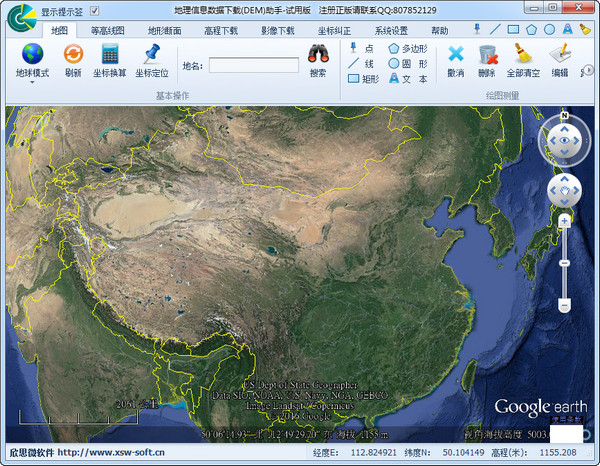
(1) Map mode: Earth, Moon and Mars modes, which can be switched at will.

(2) Draw graphics: Freely draw point (landmark), line (path), surface (triangle, rectangle, polygon, circle and sector) shape graphics.

(3) Measurement tools: measure the distance between two points, path length, area and peripheral perimeter of surface objects (triangle, rectangle, polygon, circle and sector).

(4) Format conversion: EXCEL data to KML files, KML files to EXCEL data, batch import and conversion of graphics (points, lines and surfaces) can be realized, and it is compatible with CSV and txt file formats.

(5) Coordinate extraction: Geographical coordinates can be extracted in batches based on landmarks, paths and polygons for the earth's land, oceans, moon and Mars, including names, longitudes, latitudes and elevation information. The spacing between sampling points can be set arbitrarily, and the optimal sampling plan can be customized. Millions (no upper limit) of elevation point data can be collected fully automatically at one time, with no time or quantity restrictions.

(6) Layer settings: Map layers can be displayed and turned off, and the display status can be easily switched at will.

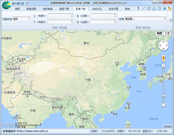
(7) Location search: The location can be automatically searched based on the input longitude and latitude, or the longitude and latitude can be searched based on the address (place name) to achieve precise positioning.

(8) Coordinate unit conversion: "Decimal degree" unit coordinates and "degrees, minutes and seconds" unit coordinates can be converted to each other.

(9) Import and export: KML files can be imported and KML files can also be exported, making the software data format compatible with other software formats.

FAQ

Geographic Information Data Download (DEM) Assistant

Geographic information data download (DEM) assistant v2017 official version

close