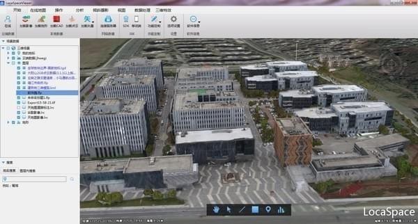
LocaSpace ViewerBasic introduction
LocaSpace Viewer (LSV) 3D digital earth software, a small, professional, green image, elevation, and oblique photography data reader, supports Google Earth images and terrain data can be quickly downloaded and used offline. It can realize the perfect combination of Google Maps and Sky Map images; free downloading of images and terrain; simple and fast implementation of surveying, mapping and annotation; extremely fast browsing of oblique photography data, multiple analyses; and more practical analysis functions.
LocaSpace ViewerSoftware features
We share Internet map resources to create a more exciting tomorrow, with fast browsing speed and no need to go over the *wall.
LocaSpace Viewer (LSV) integrates a variety of online map resources, including Google Earth images, Google Earth terrain; Baidu maps, images, annotations; Tiantu maps, images, annotations and Microsoft maps, images, annotations. The software also provides a local map source interface to easily access various types of external image sources.

The fast indexing and browsing technology of oblique photography models achieves truly powerful all-element spatial measurement and single functions in seconds.
LocaSpace Viewer (LSV) supports extremely fast browsing of oblique photography data. Supported oblique photography 3D model formats include *.osgb, *.dae, etc. The software indexes the osgb block file to generate an lfp file, which facilitates the rapid positioning of the oblique photography 3D model on the earth.
LocaSpace Viewer (LSV) uses vectorization to realize the single unitization of buildings, roads and other ground objects at the rendering level through superimposed vector bases.

This is a practical and fun 3D GIS software
Supports all types of 2D and 3D data, covering a variety of featured applications.
LocaSpace Viewer (LSV) can take you to fly and roam anywhere on the earth. You can see the undulating mountains and sparkling oceans.
You can load and analyze your two-dimensional vector, raster data, three-dimensional terrain, and three-dimensional model data on LocaSpace Viewer (LSV), making the data no longer abstract.
LocaSpace Viewer (LSV) can participate in the entire process of pre-planning, field data collection, in-house production, and data release in the operation process, making it a convenient and practical 3D GIS platform. Tools have always been our goal.
LocaSpace ViewerSoftware features
1. Massive map resources:
LSV has rich map resources, supports loading hundreds of image sources, and can perform seamless map switching after loading. In addition, various desired effects can be achieved by overlaying maps and transparent images.
2. Fast data loading:
LSV can load various types of data (including vectors in KML, SHP, CAD and other formats; raster data in TIF, IMG, MBT, Lrp and other formats; DEM data in tif, img, hgt, dem, etc.;
osgb的倾斜实景数据;obj、3ds的人工模型数据等);
You can load data by loading in the menu bar or by dragging and dropping directly.
3. Free data download:
Through LSV, various types of images and terrain data can be downloaded with simple operations.
4. Convenient three-dimensional analysis:
There are three-dimensional model analysis tools in LSV, which are convenient and efficient, and can be used to analyze and operate three-dimensional models.
5. Quick contour preview:
In LSV, you can generate contour lines for terrain maps, and you can also preview contour lines directly in LSV.
6. Practical photo tools:
In LSV, you can generate photo trajectories for photos that have already been taken, so that you can more intuitively see the location information corresponding to the photos and the trajectory of the photos taken.
LocaSpace Viewer update log
1. The details are more outstanding!
2.BUG gone without a trace
Huajun editor recommends:
The editor of LocaSpace Viewer personally tested this software and found that the various functions are very simple and easy to operate. Even a newbie like me can quickly master it. I highly praise it! There are similar software on this siteGoogle Earth Chinese version,Shanghai World Expo Online Tour,Hydrological Frequency Intelligent Analysis System,China high-speed rail map 2018 HD version,KStars, recommend everyone to download!


Useful
Useful
Useful