


LRailplan railway line design system software features
1. Full-process integrated solution for horizontal, vertical and horizontal design of railway, subway and urban rail lines.
2. Project management model, with up to 999 axis management capabilities. The system uses project management throughout the entire process of line plane and longitudinal section design. The project axis and longitudinal section manager allows designers to manage complex plans in an orderly manner. Achieve seamless handover under frequent deployment of project personnel and get started immediately.
3. The software design draws on the advanced unit normal line concept, which overcomes the lack of flexibility of traditional wire normal lines, is more adaptable to line routing under various complex terrains and control elements, and realizes the designer's intention quickly, flexibly and accurately.
4. The function covers the entire process of existing line fitting and reconstruction, and can also be used for rapid fitting and reconstruction of subway line plane and longitudinal section completed line positions. The entire longitudinal section of the existing line is automatically sloped, and the design of the longitudinal section is completed efficiently and accurately.
5. Parametric definition of cross-section types can flexibly realize rapid roadbed design of personalized cross-sections such as variable-width multi-spokes, corrugated road crowns, etc.
6. The system architecture is based on the separation mechanism of design and drawing. The system can be applied to personalized drawing output in different industries and different schemas, and can also be applied to localized drawing output in different languages. With schema version revision, designers only need to modify the schema definition and drawing convention files themselves to solve design output problems.
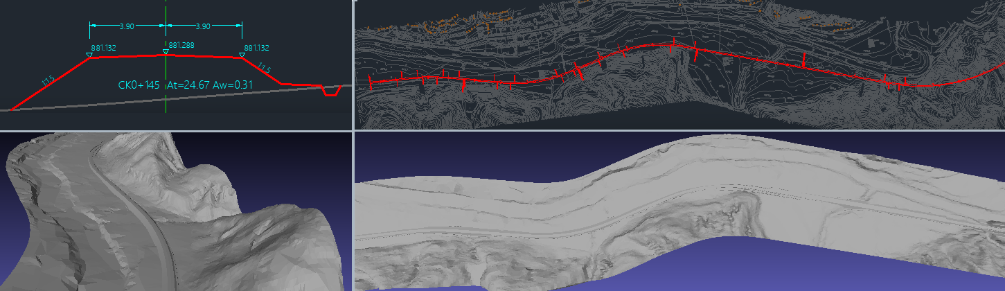
7. Point cloud rapid modeling facilitates rapid interpolation calculations of longitudinal and cross-sections for program research and rapid delivery of initial plans for bridge and tunnel construction sites, reducing the monotonous "physical expenditure" of designers.
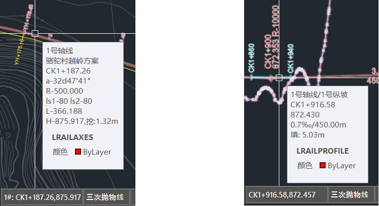
8. Design mouse hover prompt technology during the interaction process to avoid frequent zooming and dragging of the graphics screen by entity queries. The original non-command state "point and translate" type of entity information guidance greatly improves human-machine affinity.
9. To support the Belt and Road Initiative, adapt to international development, and provide comprehensive bilingual interface support in Chinese and English. The unified installation version allows you to switch the interface language independently during use.
10. Implement the localization initiative and launch LRailplan for GstarCAD (Haochen CAD) in parallel. Based on the domestic independent graphics platform, the functions of LRailplan for GstarCAD are fully covered AutoCAD improves the cost-effectiveness of your company's software investment.
11. Railway cross-section design and associated line strip 3D model. Model files can be seamlessly imported into various BIM software platforms, fully improving the data value of forward design and BIM modeling efficiency.
LRailplan railway route design system update log:
1. Upgraded to support multiple versions of AutoCAD: AutoCAD 2015-AutoCAD 2026, a total of 12 platform versions.
2. Added functions such as line strip 3D model generation and terrain profile query.
Huajun editor recommends:
The operation steps of the LRailplan railway line design system are very simple and very fast, so users can use it with confidence. Also recommendedHaochen CAD,Yaochuang CAD,vray for 3dmax2015,CAD Viewer,Quick CAD viewing softwareDownload and use related software.


Useful
Useful
Useful