


- Green versionView
- Green versionView
- Green versionView
Function introduction
Support visual new tasks
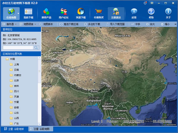
The software supports visual new tasks. Click the "Online Map Browsing" tab in the main window to switch to the map browsing window, click the "Frame Select Download Area" button on the toolbar, draw a selection box for the range to be downloaded in the view, and then double-click the mouse in the selection box to start a new task.
Support digital new tasks
The software supports digitally creating new tasks. Click the "Download Task List" tab to switch to the task list, and click "New Task" on the toolbar. You can start a new download task by entering the coordinates of the lower left corner and the upper right corner of the desired download range.
Supports multi-tasking and simultaneous downloading
The software supports multi-task downloads at the same time, but no more than five.
Support multi-threaded high-speed downloading
The software supports multi-threading. By default, ten download threads are enabled for each task to improve download speed. This number of threads is not provided to the user for the time being.
Supports scheduled task downloads
The software supports scheduled task downloads. When there are more than five tasks currently in download status, all newly created tasks or tasks that attempt to turn non-download status tasks into download status will be in scheduled task status. Whenever a download task is completed, the tasks in scheduled status will enter the download queue in turn.
Support task resumption at breakpoints
The software supports task resumption at breakpoints. If the task currently being downloaded is interrupted due to human or non-human factors (such as power outage or other unpredictable reasons), when the task is downloaded again, the task will continue from the last interrupted location without having to start downloading from the beginning.
Support automatic shutdown after completion
The software automatically shuts down after the support is completed. When the download task is heavy, the software can be left unattended and shut down automatically after completing all download tasks. To do this, just right-click on the tray image in the upper right corner and select "Shut Down When Done" from the menu.
Place name labels can be displayed overlaid
Select the "Label" option when creating a new task. In addition to a new satellite map task, a new label task of the same scope will also be created. After the two tasks are downloaded, select the satellite map task and export the download results. The place name label information can be superimposed on the satellite map.
Accurate coordinate files can be generated
The software can generate precise coordinate files, which will help us accurately overlay the downloaded pictures into other software. To implement this function, you can select the "Generate JGW coordinate file" or select the "Generate TXT coordinate file" check box when exporting the stitched image according to actual needs. It should be noted that the coordinates generated when switching to a "foreign server" are completely consistent with GE, but if there is an error between GE and the real coordinates, the generated coordinates will also have errors.
Intelligent analysis complete download
When the software downloads, it will record the download status of all pictures. If the download fails, the corresponding point status of the picture will be red. If there is no data to download, the corresponding point status will be blue. When a round of downloading is completed, all red failure points will be automatically downloaded again, and the data-free area will be automatically filtered until the download is complete.
Seamless splicing of single large images
By default, the software can seamlessly splice into a single large GeoTIFF or GeoJPEG image. However, if the image cannot be opened because it is too large, you can select "Generate multiple large images".
Automatically upgrade and update online
The software can be automatically upgraded online. When it asks you whether you need to update, it is strongly recommended that you select "Yes" to ensure that you can normally use the new features we have developed.
Change log
*Drop-down menu bug fix
*Export function bug fix


Useful
Useful
Useful