


 You may like


HD satellite map highlights
Visual experience:
Users generally believe that the satellite images provided by the APP are of high definition and the 3D maps are realistic, which can bring an immersive tour experience.
Functional practicality:
Functions such as tourist attraction navigation and offline map downloads have been well received by users, who believe that these functions are very useful in travel planning, outdoor adventure and other scenarios.
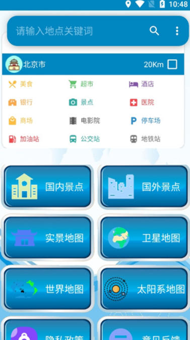
High Definition Satellite Map Features
Remote sensing data support:
Relying on the powerful remote sensing data service system of the Remote Sensing Market Cloud Platform, it breaks the traditional remote sensing industry's high threshold and difficulty in image acquisition, and integrates high-definition remote sensing images into lightweight applications.
Switching between multiple types of maps:
By integrating multiple types of maps, users can switch between satellite maps, traffic flow maps, real-time weather maps and other modes according to their needs to obtain richer reference information.
Real-time updates and precise positioning:
The Beidou mobile phone positioning image is updated in real time every day, making the positioning more accurate and supporting real-time location status display, including longitude and latitude, speed measurement function, etc.
User friendly design:
The interface is simple and the operation is smooth. It supports zooming in and out of the map freely, and you can experience clear images in real time.
Providing a "Guide" function, users can easily discover interesting new places and browse selected virtual travel routes around the world.

HD satellite map function
High-definition satellite image browsing:
It provides satellite images of real global landforms and supports dynamic updates of high-resolution satellite images across the country every day. Users can browse high-definition remote sensing images for free.
Covering domestic and foreign attractions, it supports marking "have been" or "want to go" based on the cover of the attraction to create a personalized travel footprint.
3D map and city tour:
It supports domestic and foreign 3D three-dimensional map display. The buildings adopt 3D models, and users can experience the feeling of flying over the city.
Selected cities such as San Francisco, Boston, and Rome provide a tour experience completely recreated in 3D.
Tourist attraction navigation and planning:
Supports the navigation display of tourist attractions. Users can view all scenic spots in a province with one click, obtain the most comprehensive arrangement of scenic spots, and easily make travel plans.
Provides map positioning and sharing functions to facilitate users to plan their itinerary and share it with others.
Offline map download:
Supports offline map downloading. Users can use downloaded maps without connecting to the Internet to meet navigation needs in no-network environments.

HD Satellite Map FAQ
Positioning is inaccurate or cannot be positioned:
Possible reasons: weak GPS signal, poor network signal, device setting issues (such as positioning services not being turned on or improper location mode selection), GPS hardware failure, interference from other applications, etc.
Solution:
Make sure the device is in an open area and avoid places with large signal obstructions such as high buildings, tunnels, and dense forests.
Check whether the device location service is turned on and set to high-precision mode.
Update the app to the latest version to fix known positioning bugs.
Restart the device to resolve temporary software glitches.
Clean up background applications to prevent other applications from interfering with positioning functions.
HD satellite map update log:
1. Fixed several bugs;
2. Optimize details;
Huajun editor recommends:
The functions of the high-definition satellite map are as complete as those of the official ones, the interface is more beautiful and elegant, and the design is more complete. Welcome to download to continuously meet the needs of users. Those who are interested can also downloadAotu Car Rental,Google Earth 2021,OnStar,Xingruan Auto Link,360 search map


Your comment needs to be reviewed before it can be displayed