Fleet Online Software Introduction
The fleet online app can be used for ship positioning, fleet management and auxiliary operations. In addition to providing global AIS data, it also provides global nautical charts, marine weather forecasts, typhoon forecasts, historical tracks, navigation warnings and other information, as well as route review, weather navigation, alarms, ship filtering, pre-arrival ship and other functions. Tens of thousands of inland, coastal and ocean shipping companies, such as COSCO Shipping Lines, are enjoying timely, accurate and stable data and information services brought by fleet online.
Fleet Online Software Features
Global real-time data coverage
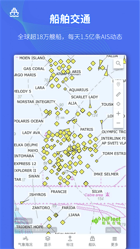
Access to 3,000 shore-based AIS base stations and 79 AIS satellites around the world, and update more than 150 million ship dynamic data every day, covering more than 180,000 ships.
Supports querying the real-time location of any ship in the world through ship name, IMO number, MMSI code or call sign.
Multi-dimensional weather and sea state forecast
Provides global water pressure, wind field, wave height, and ocean current forecasts for the next 15 days, as well as port sea state weather forecasts for the next 5 days.
Supports linkage deduction of weather data and routes to help users adjust routes in advance to avoid severe weather.
Intelligent route planning and risk warning
Based on historical trajectories and customary route databases, intelligently plan port-to-port routes and avoid risk points such as high wave areas and sensitive areas.
Provides typhoon avoidance simulation function and supports simultaneous simulation of multiple typhoons to improve navigation safety.
Rich ship archives and historical data
Contains detailed files of more than 180,000 ships around the world, including construction information, management information, tonnage, cabin capacity, etc.
Supports querying historical trajectory data since 2016, with a maximum query time span of 3 months.
Multi-platform adaptation and efficient updates
Supporting iOS and Android systems, the APP operates the same as the PC web version and maintains weekly iterative updates.
Provides night mode to adapt to night sailing scenarios on board ships.
Fleet Online Software Features
Ship real-time tracking and trajectory playback
The ship's position is displayed in real time on the chart, and historical trajectory animation playback is supported. Multiple ship trajectories can be displayed at the same time for teaching, accident accountability and other scenarios.
Route Forecasting and Planning
Intelligently predict ship routes based on AIS destination port information and provide ETA (estimated time of arrival) calculations.
Supports manual adjustment of routes, calculation of voyage distance and time, and generation of reference routes.
Fleet management and early warning system
Supports customized fleet management, distinguishes different colors to identify different ships, and sets early warnings for arrivals, departures, severe weather, earthquakes, etc.
Provides electronic fence function to monitor whether the ship deviates from the planned route.
Marine meteorology and navigation services
Wind, waves, currents, air pressure and other elements are overlaid and displayed in the form of weather fax charts, supporting the joint deduction of routes and weather.
Provides 10-day marine weather forecast and simulated navigation.
Commodity Shipping Tracking
Track the maritime movement dynamics of global iron ore, crude oil, coal, LNG, LPG and other bulk commodities, and provide transportation volume statistics and analysis.
Data interface and visualization services
Provides shipping big data API, supports visual development, and meets the differentiated needs of scientific research institutions, government agencies, etc.
Fleet Online Software FAQ
How to check the real-time position of a ship?
Open the APP, click on the search box in the upper right corner, and enter the ship name, IMO number, MMSI code or call sign to view the ship's real-time location and detailed information.
How to check the historical trajectory of a ship?
Enter the ship details page and select the "Historical Track" function, which supports filtering by time range and can query data for up to 3 months (VIP users can trace back to 2017).
How to set route warning?
On the fleet management page, select the target ship, click the "Settings" icon, and turn on the "Early Warning Reminder" function. You can customize early warning conditions such as arrival, departure, and severe weather.
Fleet Online Update Log
1. Fixed several bugs;
2. Optimize details;
Huajun editor recommends:
The editor promises that as long as you use Fleet Online, if you don't like it, you can come and hit me! The editor has also prepared for youAotu Car Rental,Google Earth 2021,OnStar,Xingruan Auto Link,360 search map


 You may like


Your comment needs to be reviewed before it can be displayed