Six feet outdoor circuitSoftware function
Track record:
Accurately records every scenery you walk through, supports the addition and sharing of text, pictures, videos and other multimedia footprints, and wonderfully records every outdoor travel track you take.
Road network tracking:
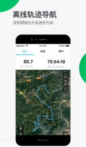
It supports adding multiple reference routes to the same destination at the same time. Different routes have different colors. You can plan your own unique route according to your actual situation, so that outdoor travel is safe and guaranteed. At the same time, it supports offline trajectory navigation. Even if there is no network, it relies on satellite GPS signals to work and you will not get lost wherever you go.
Outdoor Map:
Switch freely among 6 professional maps including Google Street View, Google Satellite, Google Terrain, OCM (Contour Line), OSM (Street), and Amap, and support free download of high-definition offline maps.

Six feet outdoor circuitSoftware Highlights
1. "Six Feet" provides free tour map tracks, search locations, and one-click query for routes.
2. Download offline maps, save traffic, and enjoy outdoor excitement in one step.
3. With powerful route inquiry and planning capabilities, you can say goodbye to getting lost outdoors.
4. Supports hiking, mountain climbing, cycling, skiing, self-driving, and outdoor sports.
Six feet outdoor circuitSoftware update log
1. The details are more outstanding!
2. BUG gone without a trace
Huajun editor recommends:
The six-legged outdoor line software feels really good! The editor specially tested it for this purpose, and it works really well.lemon love beauty,timbaoer,Yaoyuan.com,Kangqiang Medical Talent Network,Ledong SportsThese are all very good software tested by the editor, come and choose the one that suits you!


 You may like


Your comment needs to be reviewed before it can be displayed