
-
91 Satellite Map Assistant
- Size: 28M
- Language: Simplified Chinese
- Category: Download tools
- System: WinAll


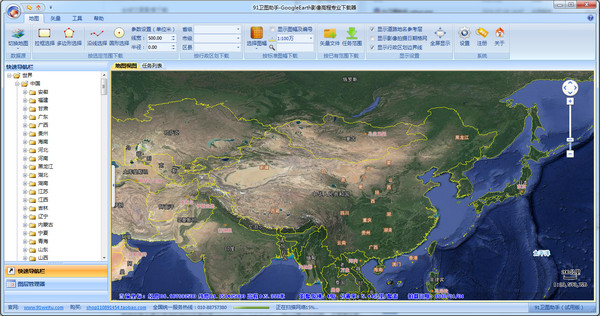
91 Satellite Map AssistantIt is the world's first truly professional downloader for Google Earth images, historical images, and elevations. 91 Satellite Map Assistant (Google Earth Edition) is the world's first truly professional downloader of Google Earth images, historical images, and elevations. It perfectly realizes direct downloading of data from the Google Earth server through a complete interpretation of the Google Earth data transmission protocol.
Software features
HD data without watermarks or offsets
Download images directly from the Google Earth server to avoid Google watermarks, and the data does not require correction or reprojection and can be directly used for professional analysis.
It supports downloading of data of any scale and format around the world. The download efficiency is 5-10 times that of ordinary tools, and it supports batch processing of massive data.
Historical image tracing and elevation data support
Provides historical image downloads from the 1930s to the present to meet the needs of time series analysis.
Supports downloading of global high-precision elevation data and directly obtains the entire elevation data to avoid point-by-point sampling errors and achieve higher accuracy.
Multi-format export compatible with coordinate systems
Supports the export of more than 20 formats such as DXF, SHP, CSV, DAT, KML, KMZ, and TXT, and is compatible with industry software such as AutoCAD, ArcGIS, and CASS.
Built-in WGS84, Xi'an 80, Beijing 54, National 2000 and local independent coordinate systems to meet the needs of different scenarios.
Independent operation and IP-free technology
No need to install Google Earth, it can still be used even if Google Earth is blocked.
By interpreting the transmission protocol, IPs are exempted from blocking and unlimited downloads are supported to avoid interruptions caused by IP blocking.

Software function
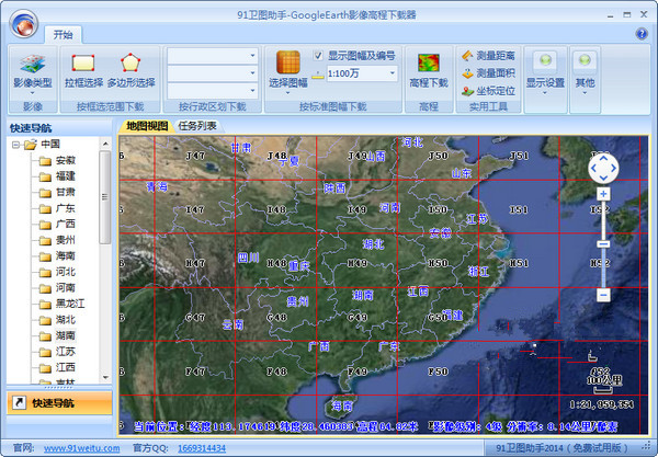
Data download
Satellite images: Download according to selected range, administrative division, standard frame or vector file range, supporting multi-screen synchronization operation.
Historical images: Filter images of specific years according to the timeline, supporting dynamic comparative analysis.
Elevation data: Download the entire elevation data to support advanced analysis such as contour line generation and terrain profile drawing.
Vector data: Download road network, water system, building outlines, POI points of interest, administrative divisions and other data, and support downloading of building outlines of 100+ cities across the country.
Data processing and analysis
Format conversion: Supports mutual conversion of KML, SHP, DXF and other formats to facilitate data sharing.
Labeling and measurement: Provides point, line, and polygon labeling tools, and supports area, distance measurement, and coordinate positioning.
Thematic layer: Generate thematic maps such as nautical maps, geological maps, vegetation coverage maps, and population maps to assist decision-making.
Industry application integration
Seamlessly connects with AutoCAD, ArcGIS, CASS and other software, supports the import of elevation data to generate contours, and improves engineering survey efficiency.
It provides image import CAD plug-ins, measurement tools, terrain analysis tools and other extended functions to meet the needs of professional users.
FAQ
Download fails or is slow
Reasons: The network is unstable, the IP is blocked, and the software version is out of date.
Solution:
Check the network connection to ensure stable and high speed.
Update to the latest version to fix known compatibility issues.
Adjust download parameters (such as resolution, tile size) to optimize download efficiency.
91 Weitu Assistant update log:
1: Brand new interface, refreshing, simple and efficient
2: Performance is getting better and better
Huajun editor recommends:
The editor of Huajun Software Park has compiled and collected software that you may like, such as Thunder Express Edition, Google Chrome, Cloud Machine Manager, etc. You can download them from this site.
Version: 19.4.0.0 | Update time: 2025-12-02
Similar recommendations


Latest updates


How to delete history in Video Pioneer? -How to delete history records by Video Pioneer
How to set the skin for Video Pioneer? -How to set skin for Video Pioneer
How to upgrade software in 360 Software Manager? -How to upgrade software in 360 Software Manager
How to draw a lottery in 360 Software Butler - How to draw a lottery in 360 Software Butler
91 Weitu Assistant Reviews
-
1st floor Huajun netizen 2018-09-03 21:21:4591 Weitu Assistant 2016 is very useful, thank you! !
-
2nd floor Huajun netizen 2019-01-19 07:24:4891 Weitu Assistant 2016 software is very easy to use, the download speed is very fast, and it is very convenient!
-
3rd floor Huajun netizen 2021-03-24 01:23:4691 Weitu Assistant 2016 has comprehensive functions and is very convenient to use.
Recommended products


- Diablo game tool collection
- Group purchasing software collection area
- p2p seed search artifact download-P2P seed search artifact special topic
- adobe software encyclopedia - adobe full range of software downloads - adobe software downloads
- Safe Internet Encyclopedia
- Browser PC version download-browser download collection
- Diablo 3 game collection
- Anxin Quote Software
- Which Key Wizard software is better? Key Wizard software collection