-
Google satellite map downloader
- Size: 38.87M
- Language: Simplified Chinese
- Category: Download tools
- System: WinAll


Google Satellite Map Downloader is a green and easy-to-use BIGEMAP Google Map Downloader. The downloader can support data correction and projection conversion functions, and the downloaded map data has no watermark, is fast, and has high accuracy. BIGEMAP Google Map Downloader can help you seamlessly stitch downloaded maps and browse to high-definition images.
Features of Google Satellite Map Downloader:
1. Download global high-definition satellite images
2. Download elevation and contour lines (vector supports CAD format dxf/dwg)
3. Provides 18 map source downloads
4. Provide projection conversion tools (image, vector) for mutual conversion between wgs84, xian80, beijing54, cgcs2000, etc.
5. Provide an altitude datum reconstruction tool (increase or lower the datum)
6. Provide plotting design tools (plotting points, lines, planes, parallel lines, importing CAD files and map integration)
How to use Google satellite map downloader:
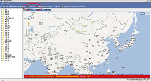
1. First open the Google satellite map downloader
2. Zoom in to the area you want to download

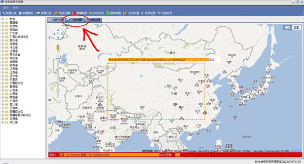
3. Select "Frame selection download area"

4. Select the download area

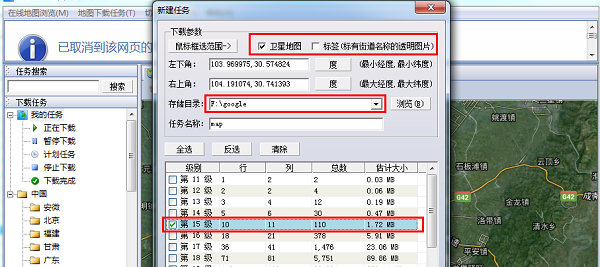
5. Select the "Satellite Map" option, arrange the storage directory, and select the map level to be downloaded.
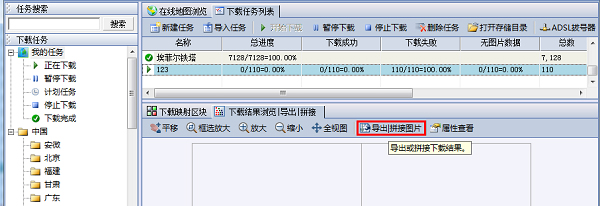
6. Click the download box and select "Browse Download Results"

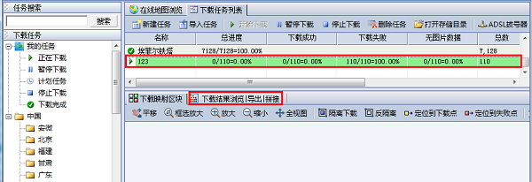
7. Choose to export or stitch pictures
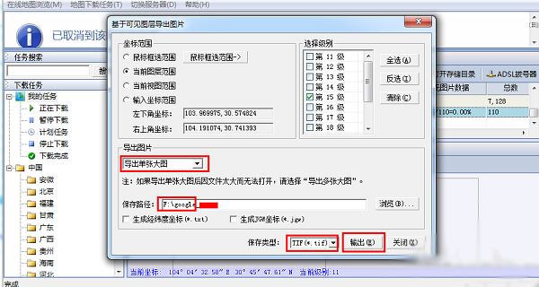
8. Select whether the exported image is a single large image or slices, determine the saving path, select the image saving type, and click "Output"
Frequently Asked Questions about Google Satellite Map Downloader:
1. What projection methods does Google Satellite Map Downloader support?
All data downloaded by Google Satellite Map Downloader contains coordinate information and projection information. The default downloads are WGS84 coordinate system, Mercator projection method or longitude and latitude method. The downloaded data supports projection conversion, and conversion to Xi'an 80, Beijing 54, CGCS2000, etc. is supported by almost all projections.
2. How clear are the satellite images downloaded by Google Satellite Map Downloader?
The satellite images downloaded by Google Satellite Map Downloader are at a scale of 1:1000 and have a high-definition pixel resolution of 0.25 meters. This means that a length of 0.25 meters in the real world represents one pixel on the map. For example, if a car is 5 meters long, then there should be 20 pixels on the map representing the length of the car.
Google satellite map downloader update log:
Beidou satellite map
Beidou Satellite Map is a powerful map navigation software that combines the top domestic Beidou navigation technology. Beidou satellite map provides users with the most accurate map location and can also measure users’ speed in real time. Beidou satellite map has powerful functions such as voice broadcast and real-time traffic conditions. You can navigate to the address you most want to visit with one click.Download address:http://softwaredownload4.com/soft/10002425.htm
Vitus satellite map
Vitus Satellite Map App, 3D Google Street View map installation software, has the most comprehensive information online query and understanding service. You can search for the latest street view maps here, view relevant instructions, and obtain AR real-life demonstration effects, allowing you to easily see the world at home, and you don’t have to worry about getting lost when you go out.
Download address:http://softwaredownload4.com/soft/10098569.htm
Google satellite map downloader update log:
1. Newly added: map annotation function
2. New: Import and export of vector data
3. New: download of the circumscribed rectangle of the special-shaped area
4. Repair: Mars coordinates are non-offset coordinates
|
Huajun editor recommends: Google Satellite Map Downloader is a very easy-to-use software. Various satellite images, terrains, and buildings can be displayed in detail and accurately here. It is a very good software whether you are traveling or learning geographical knowledge. In addition there areShuijingzhu universal map downloader,BIGEMAP map downloaderRecommended to everyone, welcome to download. |
Version: v29.6.3.0 official latest version | Update time: 2024-12-31
Similar recommendations


Latest updates


Detailed usage process of Google satellite map downloader
How to draw a lottery in 360 Software Butler - How to draw a lottery in 360 Software Butler
How to collect software in 360 Software Manager - How to collect software in 360 Software Manager
How does 360 Software Manager evaluate software - How does 360 Software Manager evaluate software?
Google Satellite Map Downloader Review
-
1st floor Huajun netizen 2021-02-10 20:42:49Google satellite map downloader software is very easy to use, the download speed is very fast and very convenient!
-
2nd floor Huajun netizen 2021-10-06 05:27:57Google satellite map downloader is not bad, the download is very fast, I give you a good review!
-
3rd floor Huajun netizen 2021-03-10 06:32:26Download the Google satellite map downloader, it’s really good! ! !
Recommended products


- Diablo game tool collection
- Group purchasing software collection area
- p2p seed search artifact download-P2P seed search artifact special topic
- adobe software encyclopedia - adobe full range of software downloads - adobe software downloads
- Safe Internet Encyclopedia
- Browser PC version download-browser download collection
- Diablo 3 game collection
- Anxin Quote Software
- Which Key Wizard software is better? Key Wizard software collection