-
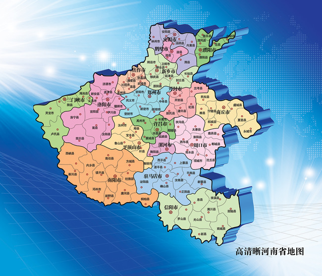
Henan map full HD version
- Size: 1.61M
- Language: Simplified Chinese
- Category: Picture viewing software
- System: WinAll


The full HD version of the Henan map contains municipal and county-level city logos throughout Henan. The full high-definition version of the Henan map supports printing and viewing on electronic devices. It fully introduces the distribution of cities in Henan Province, allowing users to better understand this city. Huajun Software Park provides you with a high-definition download of the full map of Henan.
Henan map full HD versionLocation description
location realm
Henan is located in the middle-eastern part of China and the middle and lower reaches of the Yellow River, bounded by 31°23′-36°22′ north latitude and 110°21′-116°39′ east longitude. It borders Anhui and Shandong to the east, Hebei and Shanxi to the north, Shaanxi to the west, and Hubei to the south.
topography
The terrain is high in the west and low in the east, with the Taihang Mountains, Funiu Mountains, Tongbai Mountains and Dabie Mountains to the north, west and south distributed in a semi-circular shape along the provincial boundary; in the middle and east are the Huanghuaihai alluvial plains; in the southwest is the Nanyang Basin.
Plains, basins, mountains, and hills account for 55.7%, 26.6%, and 17.7% of the total area respectively. Laoyacha in Lingbao City is the highest peak in the province, with an altitude of 2,413.8 meters; the lowest point is at the outlet of the Huaihe River in Gushi County, only 23.2 meters above sea level.
Introduction to tourist attractions in the full HD version of Henan map:
Henan Province has 358 national key cultural relics protection units, and 95 items have been selected into the national intangible cultural heritage list.
World Cultural Heritage: Longmen Grottoes, Yin Ruins, the Historical Buildings in Heaven and Earth, the Grand Canal of China, and the Silk Road.
National 5A-level tourist attractions: Shaolin Temple, Longmen Grottoes, Yinxu, Yuntai Mountain-Qingtian River-Shennong Mountain, Qingming Shanghe Garden, Baiyun Mountain, Yao Mountain-Zhongyuan Giant Buddha, Laojun Mountain-Jiguan Cave, Longtan Grand Canyon.
World Geoparks: Songshan Mountain, Yuntai Mountain, Wangwushan-Damei Mountain, and Funiu Mountain.
National key scenic spots: Songshan Mountain, Luoyang Longmen, Jigong Mountain, Wanxian Mountain Scenic Area, Wangwu Mountain, Yuntai Mountain, Yao Mountain, Qingtian River Scenic Area, Linlu Mountain, Shennong Mountain, Tongbai Mountain-Huaiyuan, Zhengzhou Yellow River Scenic Area, etc.

Version: electronic version | Update time: 2024-12-30
Similar recommendations


Latest updates


How to make a blue sky background with scratch-How to make a blue sky background with scratch
How to create a linked list in scratch-How to create a linked list in scratch
How to add local programs to scratch-How to add local programs to scratch
How to input Chinese in scratch-How to input Chinese in scratch
How to fire bullets in scratch-How to fire bullets in scratch
How to draw a fan with scratch - How to draw a fan with scratch
How to create arrows in scratch-How to create arrows in scratch
How to set the windmill rotation in scratch-How to set the windmill rotation in scratch
How to draw a spiral in scratch - How to draw a spiral in scratch
Comments on the full HD version of Henan map
-
1st floor Huajun netizen 2020-01-11 10:05:25The interface design of the full HD version of Henan Map is very easy to use and has rich functions. I highly recommend it!
-
2nd floor Huajun netizen 2020-07-15 10:22:31The full HD version of the Henan map software is very easy to use, the download speed is very fast and very convenient!
-
3rd floor Huajun netizen 2020-10-10 15:51:01The full HD version of Henan map is great! 100 million likes! ! !
Recommended products


- Diablo game tool collection
- Group purchasing software collection area
- p2p seed search artifact download-P2P seed search artifact special topic
- adobe software encyclopedia - adobe full range of software downloads - adobe software downloads
- Safe Internet Encyclopedia
- Browser PC version download-browser download collection
- Diablo 3 game collection
- Anxin Quote Software
- Which Key Wizard software is better? Key Wizard software collection