If you are looking for software to use, go to Huajun Software Park! software release AI product list

Hello, if there is a need for software inclusion, please package the software and attach the software name, software introduction, software-related screenshots, software icon, soft copy, business license (if you do not have a business license, please provide the front and back of the corresponding developer ID card and a photo of yourself holding the ID card), and send it to email http://softwaredownload4.com/sbdm/user/login

Close >>

Send to email:news@onlinedown.net

Close >>

Location: Home pageAndroid softwareApplicationmap navigation GPS navigation map - taxi, bus and subway travel

90.92%

9.08%
QR code

Scan the QR code to access the mobile version

Permissions: View

The following important permissions need to be called
uses-permission:'android.permission.INTERNET', allows the program to access the network connection, which may generate GPRS traffic
uses-permission:'android.permission.ACCESS_COARSE_LOCATION', allows the program to obtain the user's erroneous latitude and longitude information through WiFi or mobile base stations
uses-permission:'android.permission.ACCESS_FINE_LOCATION', allows the program to receive satellite positioning information through the GPS chip
uses-permission:'android.permission.ACCESS_NETWORK_STATE', allows the program to obtain network information status, such as whether the current network connection is valid
uses-permission:'android.permission.ACCESS_WIFI_STATE', allows the program to obtain the current WiFi access status and WLAN hotspot information
uses-permission:'android.permission.CAMERA', allows the program to access the camera to take pictures
uses-permission:'android.permission.KILL_BACKGROUND_PROCESSES', allows the program to call the killBackgroundProcesses(String). method to end the background process
uses-permission:'android.permission.RECORD_AUDIO', allows the program to record sound through the microphone of the phone or headset
uses-permission:'android.permission.WRITE_EXTERNAL_STORAGE', allows the program to write to external storage, such as writing files on the SD card
uses-permission:'android.permission.READ_EXTERNAL_STORAGE', the program can read files in the device's external storage space (built-in SDcard and external SDCard)
uses-permission:'android.permission.VIBRATE', allows the program to vibrate
uses-permission:'android.permission.READ_PHONE_STATE', allows the program to access the phone state
uses-permission:'android.permission.ACCESS_COARSE_LOCATION', allows the program to obtain the user's erroneous latitude and longitude information through WiFi or mobile base stations
uses-permission:'android.permission.ACCESS_FINE_LOCATION', allows the program to receive satellite positioning information through the GPS chip
uses-permission:'android.permission.ACCESS_NETWORK_STATE', allows the program to obtain network information status, such as whether the current network connection is valid
uses-permission:'android.permission.ACCESS_WIFI_STATE', allows the program to obtain the current WiFi access status and WLAN hotspot information
uses-permission:'android.permission.CHANGE_WIFI_STATE', allows the program to change the WiFi state
uses-permission:'android.permission.INTERNET', allows the program to access the network connection, which may generate GPRS traffic
uses-permission:'android.permission.READ_PHONE_STATE', allows the program to access the phone state
uses-permission:'android.permission.WRITE_EXTERNAL_STORAGE', allows the program to write to external storage, such as writing files on the SD card
uses-permission:'android.permission.ACCESS_LOCATION_EXTRA_COMMANDS', allows the program to access additional location provider instructions
uses-permission:'android.permission.FOREGROUND_SERVICE'
uses-permission:'android.permission.ACCESS_BACKGROUND_LOCATION'
uses-permission:'android.permission.INTERNET', allows the program to access the network connection, which may generate GPRS traffic
uses-permission:'com.gpsbeidou.map.openadsdk.permission.TT_PANGOLIN'
uses-permission:'android.permission.READ_PHONE_STATE', allows the program to access the phone state
uses-permission:'android.permission.ACCESS_NETWORK_STATE', allows the program to obtain network information status, such as whether the current network connection is valid
uses-permission:'android.permission.WRITE_EXTERNAL_STORAGE', allows the program to write to external storage, such as writing files on the SD card
uses-permission:'android.permission.ACCESS_WIFI_STATE', allows the program to obtain the current WiFi access status and WLAN hotspot information
uses-permission:'android.permission.ACCESS_COARSE_LOCATION', allows the program to obtain the user's erroneous latitude and longitude information through WiFi or mobile base stations
uses-permission:'android.permission.REQUEST_INSTALL_PACKAGES', allows access to installed applications from unknown sources
uses-permission:'android.permission.ACCESS_FINE_LOCATION', allows the program to receive satellite positioning information through the GPS chip
uses-permission:'android.permission.WAKE_LOCK', allows the background process to still run after the phone screen is turned off
uses-permission:'android.permission.QUERY_ALL_PACKAGES'
uses-permission:'com.gpsbeidou.map.permission.MIPUSH_RECEIVE'
uses-permission:'com.gpsbeidou.map.permission.PROCESS_PUSH_MSG'
uses-permission:'com.gpsbeidou.map.permission.PUSH_PROVIDER'
uses-permission:'com.meizu.flyme.push.permission.RECEIVE'
uses-permission:'com.gpsbeidou.map.push.permission.MESSAGE'
uses-permission:'com.meizu.c2dm.permission.RECEIVE'
uses-permission:'com.gpsbeidou.map.permission.C2D_MESSAGE'
uses-permission:'com.meizu.flyme.permission.PUSH'
uses-permission:'com.coloros.mcs.permission.RECIEVE_MCS_MESSAGE'
uses-permission:'com.heytap.mcs.permission.RECIEVE_MCS_MESSAGE'
uses-permission:'com.vivo.notification.permission.BADGE_ICON'
uses-permission:'com.asus.msa.SupplementaryDID.ACCESS'
uses-permission:'android.permission.CHANGE_NETWORK_STATE', allows the program to change the network status, such as whether it is connected to the Internet
uses-permission:'android.permission.REORDER_TASKS', allows the program to reorder the running tasks of the system Z axis
uses-permission:'freemme.permission.msa'
uses-permission:'android.permission.BLUETOOTH', allows the program to connect to paired Bluetooth devices
uses-permission:'android.permission.BLUETOOTH_ADMIN', allows the program to discover and pair new Bluetooth devices
uses-permission:'android.permission.ACCESS_GPS'

GPS navigation map-taxi, bus and subway travel 2.4.8

Special area
Software size:76.82 MB
software language:Simplified Chinese
Software rating:
Software type:Domestic software
Software licensing:shareware
Update time:2025-08-08
Application platform:Android
Software classification:map navigation
version:2.4.8
Registration number:Fujian ICP No. 2021002993-4A
Software vendor:Pure Black Technology (Xiamen) Co., Ltd.

Software introduction Related topics FAQ Download address

Basic introduction
GPS navigation map-taxi bus subway travel section first LOGO
GPS navigation map integrates domestic mainstream map navigation, covering 2D and 3D maps. It is a map navigation that can make you more efficient and convenient when taking a taxi, bus, subway, and traveling. Huajun Software Park provides the official download address of the GPS navigation map-taxi, bus and subway travel app. Users in need can download and use it for free!

GPS Navigation Map-Highlights of Taxi, Bus and Subway Travel


Map Navigation‌: Provides accurate and intelligent navigation for a variety of travel modes including driving, taxiing, bus, cycling, walking, trucks, motorcycles, new energy, etc. It can display traffic conditions in real time, avoid congested routes in advance, and estimate arrival time. When traveling in a team, you can know the location of your teammates in real time, and use the navigation intercom function to ensure that your teammates do not "lost contact". It also has the "Hello Xiaode" voice assistant and a variety of special voice packages such as Wang Hedi and Li Xueqin.

‌Amap Taxi‌: As an aggregation platform, you can call vehicles on multiple networks and platforms with one click. It is fast and can compare prices on multiple platforms in real time, making the price cheaper.

‌Public transportation‌: It has public transportation mode, and the surrounding bus and subway information is clear at a glance. The real-time bus function allows users to take the bus without waiting and know where they are going.

‌Life Service‌: Support multi-network price comparison for millions of hotels, and provide 7×24-hour service guarantee. Tickets for domestic scenic spots can be ordered at a discount, and you can use them whenever you want and return them with peace of mind. There are also considerate services such as buying flowers, refueling, and getting coffee on the way, as well as a charging map function to facilitate users to find charging piles.
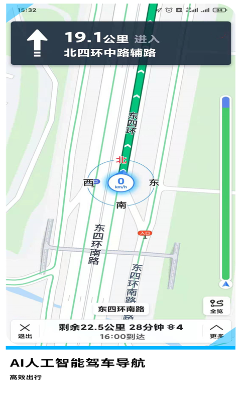
GPS navigation map - screenshots of taxi, bus and subway travel

Software features:


1. Accurate navigation without deviation and real-time synchronous update of rural road maps perfectly solves the problem of real-time update of various rural roads and road conditions during map navigation, including remote rural roads.

2. Accurate display of longitude and latitude geographical location coordinates. Accurate longitude and latitude geographical location coordinates (accurate to 6 digits after the decimal point) are provided for free around the world, which can be copied and used by users.

3. Super strong signal, real-time synchronous star-finding function, never dropped. The world's four major satellite navigation systems have real-time synchronous star-finding function, GPS navigation, Beidou navigation, GLONASS navigation, and Galileo navigation. The four major satellite navigation systems can effectively ensure that users can receive satellite navigation signals in every corner of the earth.

4. Satellite map 3D function The 3D satellite map function is similar to Google Earth of Google Maps. Users can search for specific areas on the map from a bird's-eye view, zoom in and out of the map, and then form a travel guide.

5. Convenient and practical query: Users can check real-time bus, subway, epidemic situation, calendar, weather, airplane, flight, hotel, 12306, 12123, bus arrival and other practical information on the GPS navigation map.
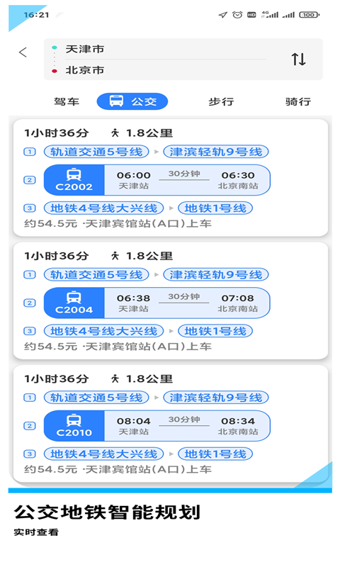
GPS navigation map - screenshots of taxi, bus and subway travel

GPS Navigation Map - Frequently Asked Questions about Taxi, Bus and Subway Travel


Software crashes or crashes

Try restarting the software or phone to resolve possible system conflicts or cache issues.

Check if the software is the latest version, if not, please update to the latest version.

If the software crashes or crashes frequently, it is recommended to uninstall and reinstall it, and contact customer service to report the problem.

Too many software ads

Check the software settings to see if there is an option to turn off ads.

If too many software advertisements affect the user experience, you may consider purchasing the membership service or premium version of the software to remove the advertisements.

You can also contact customer service to report advertising issues and make suggestions for improvements.

GPS navigation map-taxi bus and subway travel update log:


1: Brand new interface, refreshing, simple and efficient

2: Performance is getting better and better

Huajun editor recommends:

GPS navigation map - taxi, bus and subway travel software feels really good! The editor specially tested it for this purpose, and it works really well.Google Earth 2021,Tantu offline map,OnStar,Xingruan Auto Link,360 search mapThese are all very good software tested by the editor, come and choose the one that suits you!

Related topics

  • Map navigation software area

    Map navigation software area

  • Taxi hailing software area

    Taxi hailing software area

FAQ

GPS navigation map - taxi, bus and subway travel

GPS navigation map-taxi, bus and subway travel 2.4.8

Close