How to measure distance on Google Earth - How to measure distance on Google Earth
Time: 2022-09-25Source: Huajun Software TutorialAuthor: Qingchen
Many people don’t know how to measure distance using Google Earth? The article brought to you today is about Google Earth.
If you still don’t know the method of measuring distance from earth, let’s learn it with the editor.
Step 1: Open Google Earth.

Step 2: Use the mouse wheel to zoom closer to the earth and find the place where you want to measure the distance.

Step 3: Click the (Tools) button above.
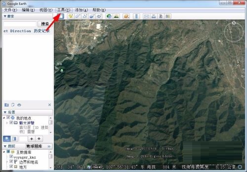
Step 4: Select the (Ruler) option.

Step 5: Use the mouse to draw the distance you want to measure on the map.

Step 6: The measured distance will appear in the ruler window, click Save.

The above is the entire content of how to measure distance on Google Earth brought to you by the editor. I hope it can help you.
Popular recommendations
-
-
Picture new earth
Version: latest versionSize: 231.40MB
Tuxin Earth official version is a very popular, professional and practical 3D digital earth software. Tuxin Earth official version software is powerful and provides online map browsing...
-
Google Earth Chinese version
Version: 7.1.5.1557 latest versionSize: 24.2M
Google Earth integrates Google's local search and driving guide services to provide a bird's-eye view of the world and will replace current desktop search software. He can be virtual...
-
Google Earth
Version: v1.3.1.6 official versionSize: 2.1MB
Google Earth is a mapping software developed by Google. Google Earth uses Google's satellite technology to cover anywhere in the world...
-
Ultra high definition world map
Version: Chinese versionSize: 27.81MB
The ultra-high-definition world map is displayed to everyone in a flat form. It is drawn using map projection. It is expressed with marks, graphics and text on the flat surface, with longitudes, latitudes...